
Turkey has unveiled its own marine spatial planning map, submitting it to UNESCO in what appears to be a retaliatory move against Greece’s recently announced plan to establish a marine protected area in the southern Aegean.
According to tovima.com, the Turkish map effectively splits the Aegean Sea in half, reviving long-standing claims that disregard the maritime rights of dozens of Greek islands. It grants these islands only six nautical miles of territorial waters and ignores provisions of the UN Convention on the Law of the Sea (UNCLOS), which Turkey does not recognise in the Aegean.
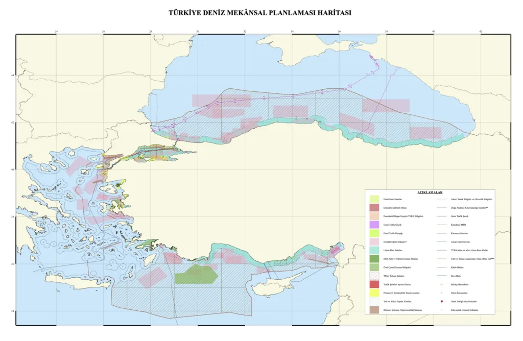
The map features a red demarcation line stretching from the Evros Delta on the Greek-Turkish land border, through the central Aegean, down to the southern Dodecanese. This line represents what Ankara considers the maritime “midpoint” between Asia Minor and mainland Greece — a concept rejected by international legal norms.
Further additions include diagonal zones in the eastern Mediterranean, reflecting hydrocarbon exploration areas allocated to Turkey’s state energy company TPAO. Pink-shaded zones indicate permanent Turkish military firing ranges, while a black line crossing north of Crete is labelled as a proposed undersea cable route.
Greece responded swiftly. In a statement, the Greek Foreign Ministry said: “Turkey today published a maritime spatial plan in response to a Greek plan, which is already part of the European acquis. The difference is that the Turkish map has no basis in international law, as it attempts to usurp areas of Greek jurisdiction, and is not addressed to an international organisation that imposes an obligation to post such relevant maps.
“Therefore, it does not produce any legal effect and is simply a reflexive reaction of no substance. Greece will insist on its principled policy and calls on Turkey not to table maximalist claims, which everyone understands are for internal consumption only. Greece will take all appropriate action in international forums.”
Analysts note that Turkey’s move was widely anticipated following Greece’s announcement and reflects ongoing regional tension over maritime boundaries and energy exploration rights in the Aegean and eastern Mediterranean.
Source: tovima.com,